Golden Software
-
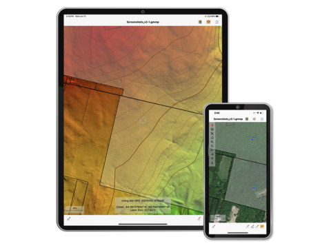
Global Mapper Mobile
Global Mapper Mobile® is a powerful iOS and Android application for viewing and collecting GIS data. It utilizes the GPS capabilities of mobile devices to provide situational awareness and locational intelligence for remote mapping projects. A perfect complement to the desktop version of Global Mapper, the mobile edition provides maps-in-hand functionality for engineers, surveyors, wildlife managers, foresters, and anyone whose job requires access to spatial data in remote locations.
Call for priceGlobal Mapper Mobile
Call for price -
MangoMap Extension
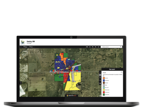
Global Mapper® Extension for MangoMap
Beginning with version 21 of Global Mapper, users can publish map data to an online map using MangoMap, providing a simple and efficient way to share geospatial data on any computer or mobile device.
Call for priceMangoMap Extension
Call for price -

Didger
Amp up your geoprocessing toolbox.
DIDGER HAS RETIRED
We no longer sell Didger, but don’t worry! The answer to your Didger question is a click away…Did you know a number of Didger features are available in our 2D & 3D mapping, modeling, and analysis software application, Surfer? If you’re looking for outstanding interpolation methods, check out the free Surfer trial!
Call for priceDidger
Call for price -

Strater
Eliminate subsurface uncertainty.
STRATER IS RETIRED
Don’t worry! We’re still here to help.
Strater is officially retired, but you can still purchase additional licenses as needed. Please note, Strater is sold as-is and will not receive updates, fixes, or new features. We will continue to provide technical support to the best of our abilities.Call for priceStrater
Call for price -

MapViewer
Make the most of your spatial data.
MAPVIEWER HAS RETIRED
We no longer sell MapViewer, but don’t worry! The answer to your MapViewer question is a click away…
Did you know a number of MapViewer features are available in our 2D & 3D mapping, modeling, and analysis software application, Surfer? If you’re looking for outstanding interpolation methods, check out the free Surfer trial!
Call for priceMapViewer
Call for price -

Voxler
Power forward into 3D visualization
VOXLER IS RETIRED
Don’t worry! We’re still here to help.
Voxler is officially retired, but you can still purchase additional licenses. Please note, Voxler is sold as-is and will not receive updates, fixes, or new features. We will continue to provide technical support to the best of our abilities.Call for priceVoxler
Call for price -

Grapher
Gain deeper insight into your data.
Visualize Data
Present your data at its best. Grapher offers high-quality graphing tools so you can get the most out of your data. Grapher provides over 80 different 2D and 3D graphing options to suit multiple industries, from geology and hydrology to environmental work and construction.
Grapher is a full-featured scientific graphing package, allowing the user to import data in many formats, create and combine a wide variety of 2- and 3-D plot types, and customize the plots in infinite detail.
David Suder, Principal Scientist
Precise Environmental ConsultantsCall for priceGrapher
Call for price -

Surfer
Explore the depths of your data
Visualize Data
You work hard gathering your data. Don’t settle for subpar visualizations.
Utilize Surfer’s extensive modelling tools to display your data the way it deserves while maintaining accuracy and precision.
Clearly communicate information related to geology, hydrology, environment, construction and more with Surfer.Call for priceSurfer
Call for price